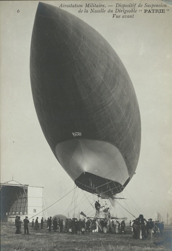
Maps

3 Comments

There's been a huge amount of interest on Twitter and in the media about the new Bomb Sight website, developed by the University of Portsmouth with assistance from the National Archives and elsewhere, and deservedly so because it's fairly excellent. In short it's an interactive map of the London Blitz compiled from a number of sources, showing where what kinds of bombs fell when. So you can browse to (or search for, though this has been temporarily disabled due to high traffic) your favourite part of London and see why there's a mid-20th century building interrupting that otherwise Victorian facade. Zooming in you see a marker for each bomb fall, with a link for more information. You can also get a statistical overview for each borough or ward, or for Greater London as a whole. Each location links in with relevant Blitz photographs sourced from the IWM, as well as related stories from the BBC's WW2 People's War site. In the map view, you can flip between the aggregate bomb census over seven months, or a single week's worth of bomb falls, or just the first twenty-four hours. You can also overlay the original Home Security maps from which the census data is derived, which is valuable because, thanks largely to the Blitz itself, some streets which existed in 1940-1 can no longer be found. As a bonus, London's invasion defences can also be displayed, using data taken from the Council for British Archaeology's Defence of Britain Dataset. An AR app is on its way, though sadly only for Android devices, not iOS.

Despite popular impressions, Bomb Sight doesn't show all the bombs recorded falling on London during the Blitz, but only those recorded between 7 October 1940 and 6 June 1941 as well as those recorded on 7 September 1940. That is, nearly the first month of the Blitz is missing. (This is quite clearly stated but it would be easy to overlook.) The reason for this is that the weekly bomb census maps only began to be compiled a month into the Blitz. It might be possible to fill in the gap from other sources; that's what has been done with the first day of the Blitz, which is from London Fire Brigade records via the Guardian. Of course, coming from different sources the data will be disjointed but that is inevitable with this kind of project. I gather that it is also intended that all the weekly censuses between October and June will be added to the site, which would mean you could slide through the weeks to see how the bombardment changed over time; or else further research might pin down the date of each bomb (at the moment when you click on one it only gives the census period, i.e. up to an eight month period). It would also be extremely interesting to compare bomb falls from the First World War, if only to illustrate the differences in the scale of bombing.

Also, Bomb Sight only covers London. Again, this is at least partly due to the nature of the data sources. But again it's something which could be remedied. Other, smaller Blitz maps like this have already been done for Southampton and for the West Riding of Yorkshire (for the night of 14 March 1941; from after the Blitz there is also Londonist's V-2 map. Depending on the permissions and formats, and hand waving wildly, it should be possible to aggregate these maps into Bomb Sight, if desired. Or else somebody else could build a website to do the aggregation. But in the end, somebody would probably have to do the hard work of sifting through local ARP records to generate the data for outside London, assuming those records do exist and are detailed enough.

None of which is intended to cavil at what the Bomb Sight project has achieved, as it's very good stuff indeed.

1 Comment


View Mystery aircraft, Australia, 1918 in a larger map

My next step in characterising the 1918 Australian mystery aircraft scare was to plot all the sightings Google Maps, which you can see above. I've used differently-coloured icons for different time periods to give an idea of the progression over the course of 1918: blue is January and February; red, March; green, April; cyan, May; yellow, June; purple, July; magenta, August through November. There are too many for Google Maps to show at once in an embedded map (without me learning JavaScript) but the rest can be seen here. Each icon is named for the location and has an attached date, but no other information. I dithered over which map mode to use but in the end settled on good old satellite mode, as it gives an idea of the terrain but also has good social data such as roads and towns (even if these are from 2012, not 1918). Of course you can switch between them yourself.
...continue reading

8 Comments

Patrie

The Lebaudy-built Patrie, seen above, was France's first military airship. A descendent of the Jaune, in 1906 and 1907 it carried out a number of successful proving and publicity flights, including one where it carried the prime minister, Georges Clemenceau, over Paris. Afterwards it was moved to its operational base near the fortress of Verdun. Due to a mechanical failure during a subsequent flight it had to ground in the open, far from the safety of its hangar. A gale blew up, and even one hundred and eighty soldiers were unable to hold the stricken airship down. At 8pm on 30 November 1907, the Patrie floated off into the distance, fortunately sans crew.
...continue reading

11 Comments

Flight, 27 June 1935, 725

My main interest in this series about the RAF Displays at Hendon has been in the set pieces with which they ended. But as this is the last post it's worth looking a bit at the organisation of the Display itself. Flight had some useful articles for this in its preview of the 15th Display, held on Saturday, 29 June 1935. Above is a map showing the aerodrome, the seating arrangements, car parks, access roads and Colindale tube, which opened in 1924 and was a major boon for visitors to the Display.1 (For those who have been to the area more recently -- say to the RAF Museum or British Library Newspapers -- it's interesting to compare how the area has changed.) We can see from the seating plans some of the groups the RAF was trying to impress: there are boxes for the House of Commons, the House of Lords and public schools -- presumably with an eye to future officer recruitment. Private boxes seating six could be booked for between £4 and £7 (depending on location?); at the other end of the spectrum the groundlings could buy tickets for the least exclusive enclosures on the day for 2s., or a spot on a hillside overlooking the aerodrome for 1s.2 Attendance peaked in 1931 at 169,000 (bringing in £27,585 6s. 11d.), though including onlookers sitting in places where they didn't have to pay the figure came up to around 500,000 (or so Flight reckoned).3 The organisation of the Display was a year-round affair, with the 'display office' being closed only for a couple of weeks in August. The programme is 'usually settled fairly exactly by the beginning of the year', but by whom is not clear. The whole thing is overseen by a 'Display Committee' headed by Air Chief Marshal Sir Robert Brooke-Popham; the 'Flying-Subcommittee' chaired by Air Vice-Marshal Joubert de la Ferté handles the exciting bits; and the 'General Purposes Committee', of which Air Commodore B. C. H. Drew is secretary, organises everything else -- ticketing, liaison with transport and police, construction, etc.4
...continue reading

  1. Flight, 27 June 1935, 725. []
  2. Ibid., 726; the map is from here also. []
  3. Ibid., 727. []
  4. Ibid. []

9 Comments

Daily Mail, 15 June 1917, 6

Previously, I identified a comparison between the reprisals debate in the First World War and the reprisals debate during the Blitz as something I could do that previous writers have not (except in passing, or implicitly). I won't have time in my AAEH paper for a full-blown comparative approach, or for that matter time before then to do the research; though perhaps I could for a version for publication. But it's something I can do briefly, and it helps that I already covered this in my thesis, where I looked at the British press reactions to the Gotha summer in 1917.1
...continue reading

  1. The best published source for this is Barry D. Powers, Strategy Without Slide-rule: British Air Strategy 1914-1939 (London: Croom Helm, 1976), 81ff. []

1 Comment

So, THATCamp Melbourne is over. It was pretty much as I expected, which is to say it was excellent. I'm not going to write a conference report (you should have been following #thatcamp on Twitter for that!) but two sessions did give me ideas for digital history projects I might like to do. One day. If I get the time.

One came out of the unofficial API Tim Sherratt reverse-engineered for Trove Newspapers. (Why the National Library of Australia won't release an official API is a bit mysterious.) He uses that to scrape Trove to do searches and display results which aren't possible with the interface offered by the NLA, such as plotting the frequency of Australian vs British/Briton. Are there any publicly accessible datasets which I use which could benefit from the same treatment? Yes, there are. The first one I thought of was the Flight archive, which is a great resource burdened with a limited interface. (But it's fantastic that it exists at all: Flightglobal is a commercial operation and they didn't need to open up their back issues like this at all, if they didn't want to.) I think this is easily doable. A second one is much more ambitious: The National Archives catalogue. It's frustrating that you can't do keyword search across their digitised collections; all you can do is search the descriptions in the catalogue, and these are by their nature limited. A scraper would help here. But the problem there is that you can't download documents directly, even when they are free; you have to add to a 'shopping cart', pay £0.00 for it and wait for an email to arrive. Possibly this could be automated; possibly not.

The other idea I had was to use SahulTime (or its eventual successor, possibly called TemporalEarth) to display the British scareship waves. SahulTime is something like Google Earth, but it allows you to map events/documents/people/objects in time as well as space. Matthew Coller, the developer, originally devised it to represent archaeological data on migration into Australia across the ice-age land bridge, but it is just as useful for historical data. So I could use this to show when and where the scareships were seen, showing how the waves started and evolved, with links to the primary sources. SahulTime is also good at displaying uncertainty in time, which is helpful where I have only vague information about when a sighting happened. The same could be done for uncertainty in space, though that's a bit trickier conceptually.

One day... if I get the time...

3 Comments

Daily Mail, 7 October 1940, 1

'RAF PREPARING A GREAT NEW BOMBING OFFENSIVE', Daily Mail, page 1:

POWERFUL new R.A.F. bombers now being produced in great numbers and an amazing new long-range fighter are likely to be used, in the immediate future, for a greatly intensified bombing offensive over Germany.

Hitler's people can look forward to more than a taste of the medicine their Luftwaffe is administering over here.

'Shortest Raid. LONDON ALERT LASTS 20 MINS.':

LONDON had its usual air-raid warning half-an-hour than usual last night. It proved to be the shortest after-dark "Alert" since the blitzkrieg began, lasting barely 20 minutes.

And it was followed by the longest period of quiet.

'2-TONS OF BOMBS RAIN ON KRUPPS':

TWO tons of bombs were rained on the great Krupps arms works at Essen during a lightning high-altitude attack by the R.A.F. in Saturday night.

[...]

They started a trail of fire across Germany's oil plants and railway yards, blasting the docks in Holland, and set the French coast aflame from Dunkirk to Boulogne.

'Nazis Lose More Than They Kill':

LORD CROFT of Bournemouth, Under-Secretary for War, revealed yesterday:

"It is believed that ten days ago a single British submarine sent more German soldiers to their doom than all the British deaths caused by German airmen in the whole month of August.

[...]

"It is highly probable that far more German war factory workers have lost their lives than the total losses inflicted on our civilians from air attack."

...continue reading

5 Comments

Manchester Guardian, 18 September 1940, 5

The Prime Minister gave a speech on the war situation to the House of Commons yesterday, which I'll come back to. The Manchester Guardian has a lot on the air war, of course (5). A big wave of enemy raiders, consisting of 'more than 200 Messerschmitt and Heinkel fighters' was broken up over Kent yesterday afternoon, getting no farther than Maidstone. Losses were small on both sides, however (possibly due to the heavy clouds and the '100-mile-an-hour gale' they fought in): seven German aeroplanes were shot down, and three British. Unusually, the defenders' record was nearly as good at night: anti-aircraft guns accounted for four enemy aircraft before midnight, and fighters one. The Luftwaffe dropped bombs central London, including the West End ('There was considerable aerial activity near Green Park'), and also on 'a South-East England village':

One dropped in a roadway, making a crater and causing considerable damage to houses and a number of casualties, some of them fatal. A couple and their four children had a remarkable escape when their house collapsed and they were buried in the wreckage.

So it's not just the big cities which are having to 'take it'.
...continue reading