

View Scareships, 1913 in a larger map
Here’s where the 1913 phantom airship sightings took place. Actually, there are a few from late 1912 (including the Sheerness incident), the blue ones. Red indicates sightings in January 1913, green February, cyan March, and yellow April.
A quick visual inspection shows that the density of sightings was greatest in Lancashire and Yorkshire, in a belt running from Liverpool in the west to Hull in the east. However, this perception is skewed somewhat by the cluster of reports from about a dozen places in and around Selby on 21 and 22 February. Clearly something happened there that night, and whatever it was can in no way be discounted, but Yorkshire would stand out far less otherwise (though there would still be the sightings from around Hull and Grimsby, including that from the City of Leeds, about the last of the whole scare to generate widespread interest in the press). By contrast, the clusters around Manchester and Liverpool, though smaller, are also more sustained, with reports spread out over four or five weeks. Other significant groupings include the south-east of England and, relatively late in the scare, the east coast of Scotland. And, of course, the coastline either side of the Bristol Channel, which featured prominently in the scare from almost the first to almost the last. Cardiff was the place most frequented by mystery airships, with four visits recorded at long intervals; that the Chief Constable of Glamorganshire was one of the first to see it and was willing to publicly appeal for witnesses to come forward may help explain why hundreds or even thousands of people saw them there. Only Hull presents a similar example of a mass sighting, though there were others where smaller crowds gathered to watch the scareship. It’s also worth noting that there were occasional reports of mysterious airships from Ireland and from the Orkneys.
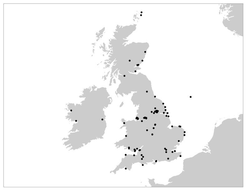
Google Maps is great for embedding into a blog post, particularly since you can zoom in for a closer look, but it’s not suitable for publication — even a screen grab would look garish. For my Australian mystery aeroplane article I made something similar to the above, just a simple distribution map (though it would be better if it had bubbles sized in proportion to the number of sightings in an area). To make this one, I exported a KML file from the Google Maps version and imported it into a free online GIS application called indiemapper [update: moved here]. I then overlaid my scareship locations onto indiemapper’s own 1:10m scale landmass shapefile data (using the physical theme rather than the cultural one, as the latter had the current international boundaries rather than the 1913 ones, though I could also have imported an appropriate historical shapefile if I’d had one). When I was happy with the result I exported it to a PNG file and here it is. There’s a lot more than can be done with indiemapper and the learning curve is far shallower than for something like ArcGIS. GIS without tears, perhaps, though also GIS without a future as it’s not clear how indiemapper will be supported in the longer term and the only GIS file format it can export to is its own. Still, in the present it’s perfect for my needs.
One thing the flatter, non-interactive version of the map does is suggest that the phantom airships had a slight bias towards seaside locations, particularly along the south and the east coasts. Isn’t that what might be expected if the phantom airships were in fact real and presumably foreign airships? Perhaps. But I think that in this respect, more important than where they were seen is the direction they were seen in, and I’ll try to explain that in a following post.
![]() This work is licensed under a Creative Commons Attribution-NonCommercial-NoDerivatives 4.0 International License.
Permissions beyond the scope of this license may be available at http://airminded.org/copyright/.
This work is licensed under a Creative Commons Attribution-NonCommercial-NoDerivatives 4.0 International License.
Permissions beyond the scope of this license may be available at http://airminded.org/copyright/.

Very interesting. I wonder if anyone has tried to compare these to the other phantom airship sightings of the prior decades. Is there any pattern that hints at something more? Or is this just another form of mass hysteria? Or something more modest? Probably the latter but who knows at this time.
Also I am a geographer who is proficient in ArcGIS and learning QGIS who loves vintage aviation so if you ever need details maps please contact me.
And now that I have read through chucks of your site I realize that making those comparisons is what you do. Pardon my ignorance.
However, my offer still stands: if you need more advanced mapping ever feel frr to contact me.
Thanks, one day I might take you up on that!