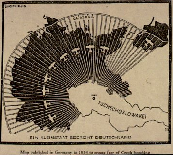
This is my third post about maps out of the last four, so I’ve given in and made a Maps category. It’s not just me: there are another three posts about maps at Breathing History, and also at Philobiblon and My London Your London about an exhibition at the British Library about maps of London. And then The War Room alerted me to a great blog called strange maps, the subject of which is just what it sounds like — fascinating and unusual maps of all kinds: historical, fictional, satirical, political. There are three Second World War era maps produced for propaganda purposes: one supposedly showing German war aims, another supposedly showing Allied war aims, and one especially interesting to me, supposedly showing a 1934 German map of a supposed aerial threat from Czechoslovakia:

The provenance of the map is not clear — it’s labelled in German ‘A small state threatens Germany’, but under that is another label in English explaining that it was ‘published in Germany in 1934 to create fear of Czech bombing’, so who knows when or where it was published in English, or even if it was ever actually published in German. My guesses would be 1938-40, a British newspaper, and yes, but the online source doesn’t say. Anyway, plotting the range of aircraft in order to demonstrate the threat of bombing was common enough by this time, as I’ve previously discussed.
There’s no doubt that Germans in the 1930s lived under the shadow of the bomber: by 1934, the Nazi-founded Reich Civil Defence League already had 2.5 million members, and the prospect of morale bombing would have been especially disturbing to believers in the Dolchstoss legend, that Germany had not been defeated in the field in 1918 but “stabbed in the back” by weak-willed civilians. Hitler described Czechoslovakia as a dagger aimed at the heart of Germany. But Czechoslovakia never came close to bombing Germany; instead it was Goering who threatened the aerial destruction of Prague, to make sure that Czechoslovakian forces didn’t resist the illegal German occupation of Bohemia and Moravia in March 1939 (sorry, I mean the liberation of Slovakia). Assuming it is actually genuine, this map would have been one small justification for the progressive German campaign against the Czechs.
![]() This work is licensed under a Creative Commons Attribution-NonCommercial-NoDerivatives 4.0 International License.
Permissions beyond the scope of this license may be available at http://airminded.org/copyright/.
This work is licensed under a Creative Commons Attribution-NonCommercial-NoDerivatives 4.0 International License.
Permissions beyond the scope of this license may be available at http://airminded.org/copyright/.


Seems perfectly reasonable to me. The Czechs had WMDs and the invasion was a pre-emptive strike.
“Hitler described Czechoslovakia as a dagger aimed at the heart of Germany.”
Which calls to mind Kissinger’s (apocryphal?) ironic reference of Chile (or NZ if you believe others): “A dagger aimed at the heart of Antarctica”
Isn’t Strange Maps a fantastic site? Glad you could find it via The War Room!
Beware of the threat that is a re-unified Czechoslovakia ;)
Quite so Russ. I think on the basis of the above projection we could frighten the buggery out of our SE Asian neighbours with a map and about a dozen Swordfish biplanes.
Jets? Who needs ’em?
I love maps and must admit I was inspired by your previous posts.
Strange maps is a great blog and one for my RSS feed.
I should note that in 1934, Germany officially had no air force, so even Luxembourg could have been deemed threatening if it owned any aircraft at all. Which it probably didn’t (it doesn’t now). Hmm … New Zealand — dagger aimed at the heart of Antarctica or the Luxembourg of the South Pacific?
I’m really only worried about the reunification of Czechoslovakia insofar as it presages the resurrection of the Austro-Hungarian Empire. Those Hapsburgs have been nursing a grudge for close to a century now, and their vengeance will be bloody. Remember Sarajevo!
Brazen propaganda, designed to justify the Germans breaking the provisions of the Treaty of Versailles prohibiting the country from having a military air force. But it was legitimate at the time. In 1934, Czechoslovakia had an air force. (Indeed, it also had the biggest arms manufacturing concern in Europe.) Germany, although it was trying to create an air force as soon as possible, did not.
If the Czechs had attacked Germany in 1934, they could have done just what this map depicts. And if Marshal Pilsudski in Poland had had his way, both countries would have attacked Germany before that crackpot Chancellor they’d just elected could create any mischief. Of course, their “allies” in Paris nixed the whole idea.
Yes, Czechoslovakia had an air force, but it was not capable of doing any serious damage to German cities as maps like this implied. It’s a German parallel to the British fear of German bombers at the same time, understandable, vastly exaggerated, propagandistic.
Source:
Rupert von Schumacher, Zeitschrift für Geopolitik 10, 1934, 645.
Thanks, Hans! From that I’ve found some secondary sources which discuss the map and put it into context, e.g. G. Henrik Herb, ‘Persuasive cartography in Geopolitik and national socialism’, Political Geography Quarterly 8 (1989), 289-303. So Zeitschrift für Geopolitik was a nationalistic but scholarly journal which started in 1923 (or 1924). The map shown here was created expressly for an article on how best to design ‘persuasive’ maps (by comparison there’s a 1929 map showing French, Polish and Czech air threats which was published in a Nazi newspaper; concentrating on the one threat here was held to be more effective). But it seems it was not itself used for propaganda as such.
Doesn’t help with where (or if) it was re-printed in a contemporary English publication though.